With corn.
In growing it. Watering it from the ancient aquifer. Overplanting it. Making unnecessary ethanol with it. Poisoning people with high fructose corn syrup. Forcing grass eating cows to eat corn which does untold things to their physiology and to the meat we eat. Misusing the land. Creating the Gulf dead zone.
Showing posts with label Dead Zone. Show all posts
Showing posts with label Dead Zone. Show all posts
Friday, November 30, 2012
Tuesday, June 14, 2011
Lions and tigers and bears, oh my!
This fossil find makes me want to watch Jurassic Park again...
How ... odd. Forecast predicts biggest Gulf dead zone ever. I wonder if the oil companies and corn growers want to make the entire Gulf of Mexico dead so they can drill for oil and ignore fertilizer run off in peace....
Sunspots are disappearing! Does that mean a little ice age is coming? On top of global warming? I'm so confused....
Thursday, May 20, 2010

Tuesday, April 20, 2010
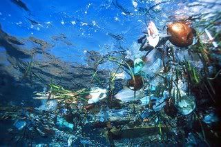
Plastic islands
Are growing apace in all of our oceans!
More excellent graphics and links here.
And the articles I've been collecting since I learned about our plastic continents and dead zones.
Update: Sadly, plastic kills.
Maximenko's Plastic Pollution Growth Model from 5 Gyres on Vimeo.
More excellent graphics and links here.
And the articles I've been collecting since I learned about our plastic continents and dead zones.
Update: Sadly, plastic kills.
SEATTLE -- Researchers said a dead gray whale discovered on West Seattle’s Arroyo Beach last Wednesday was filled with a variety of debris, reported KIRO 7 Eyewitness News.
Cascadia Research Collective, which has performed hundreds of whale necropsies, said it has never seen so much debris in the stomach of a gray whale.
Monday, March 08, 2010
I read the news today, oh boy....
Harassing three year olds for gender bending.
Well... the one family, one child thing really really worked, didn't it? Estimated 96 million women missing from the population of Asia.
Redefining Capitol Hill speak.
Romney says his Massachusetts health care isn't like Obama's even though it is.
Dinna go to warp speed, Scottie!! It'lla kill yeh!
Growing low-oxygen zones in oceans worry scientists. ... It concerns a lot of regular citizens, too, you know.... as well as fish, crabs, shrimp....
Love wins.
Saturday, January 16, 2010
Just one word.... Plastics
Plastic Plastic Everywhere: The 5 Gyres Project posted by Dave Chameides
....you’ve most certainly heard about the plastic mass that is floating out in the North Pacific Gyre. The gyre, one of several in the world, is a vortex of currents swirling inwards that lies between California and Japan. Like a toilet bowl that never flushes, it’s filled with plastic debris from man made items. So much so that from the first time it was studied until now, it has grown from the size of the state of Texas to twice the size of the continental United States!I've been fascinated by the gyres ever since I heard about them a few years ago. That and the growing Dead Zones that occur in the Gulf of Mexico and around major coastal cities.How do I know this? Simple, my friends, Dr. Marcus Erikson and Anna Cummins, along with a bevy of other scientists, have traversed it, not once, but several times, in order to study what is actually happening out there. And what they found is truly disturbing. While the plastic soup is not concentrated, meaning you wouldn’t be able to see it from the air, once you get in the water, it can’t be missed. Thousands of tiny confetti-like pieces of plastic, filling otherwise pristine waters, waiting to be ingested.
Is Plastic Making Us Fat?
Hormone-mimicking chemicals that already have a bad rap for their role as endocrine disruptors in the body (including the notorious bisphenol A (BPA)), are now thought to also screw with the body’s metabolism and, depending on the amount and timing of exposure, predispose individuals to obesity.Just one word... Plastics!
We’re surrounded by these chemicals: BPA and pthalates are everywhere, from water bottles to dryer sheets to the PVC pipes that deliver your shower water, and they’re taking their toll. Call them obesogens–a term coined by Bruce Blumberg, a leading researcher on the issue. A recent Newsweek story illustrates the increasing body of evidence that links these chemicals to the body’s metabolism.
Thursday, June 26, 2008
Awash
Early estimates suggest that the extent of the cleanup will be unlike anything some of the flooded cities have experienced. And some of what the water left behind is toxic, experts said, possibly tinged with raw sewage or chemical runoff from agriculture.Lives destroyed by flooding occurs in the ocean as well:
In Cedar Rapids alone, it is estimated that the 4,200 flooded houses are producing about a ton of debris each, mostly heavy appliances, electronics and furniture. Beyond that, businesses, schools, hospitals, churches and government offices are flooded, bringing the city’s total flood-related garbage load to about 300,000 tons, officials estimated.
A typical garbage truck can handle about four tons of trash.
“We’re looking at 10 to 15 times as much garbage as we’ve ever dealt with, so this is huge,” said Mark Jones, the superintendent of the city’s solid waste and recycling division. Backup trucks are arriving from across the state. “As you could see, it would take us forever to do this,” he said.
Des Moines, IA (AHN) - The marine dead zone resulting from the Midwest flooding is expected to expand to over 10,000 square miles, according to researchers from the Louisiana State University and the Louisiana Universities Marine Consortium.
The water in the dead zone, approximately the size of Massachusetts, does not have sufficient oxygen at depth to support marine life. Since 1990, the zone, located off the coasts of Louisiana and Texas, usually covers 6,000 square miles, varying according to the flow of the Mississippi River.
Tuesday, June 10, 2008
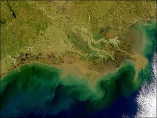
The Dead Zone
No, not Bush's skull, the Gulf of Mexico:
So where does one begin?
Update 6/11: RB of The Wicked Witch of the Web has posted on this as well as written an article.
Scientists have monitored the growth of these so-called dead zones since the late 1970s. They have tried to promote policies to reduce their size, without much success. Last summer, the dead zone along the Gulf of Mexico coast spanned nearly 8,000 square miles— its third-largest occurrence on record and roughly the size of Massachusetts.Everyone is to blame and no one will take responsibility. Finger pointing resolves nothing. In the mean time the Gulf continues to die. It's up to EIGHT THOUSAND square miles. What will the magic number be to galvanize people to act? It obviously must be from the ground up because politicians by their very nature will do nothing.Although states have tried to address the problem, cooperation among them is suffering, and federal leadership and funding are lagging. And now, scientists say, there is a new obstacle: the impact of ethanol production on water quality.
Spurred by recent ethanol mandates and, to a lesser extent, high commodity prices, U.S. farmers are planting record-size crops. From 2006 to 2007, corn acres rose by about 15 million, mostly in the Mississippi River basin. Mid-Atlantic farmers are expected to plant 500,000 more acres of corn, soybeans, and wheat this year than they did in 2006, a 7 percent jump.
So where does one begin?
Update 6/11: RB of The Wicked Witch of the Web has posted on this as well as written an article.
Sunday, March 02, 2008
One of the things predicted for the future
Was escalating fights over water and water rights, between cities and farms, between states, between neighbors.
Via Bryan of Why Now? water rights negotiations between three Southern states have broken down:
But the bill has come due:
More people, more polluted oceans and dead zones, less potable water, breaking infrastructure, more contaminates.
No politician will ever admit the world is changing as we speak. Especially the Bush Republicans. It is not good for the economy to go negative. And we're going to have to take drastic steps to change our comfortable lifestyles and habits. No politician will dare tell us to do it.
We're going to have to do it ourselves.
(Psst .. turn off your taps.)
Via Bryan of Why Now? water rights negotiations between three Southern states have broken down:
WASHINGTON - Interior Secretary Dirk Kempthorne acknowledged Saturday that White House-brokered water negotiations among Alabama, Florida and Georgia have failed.Bryan points out:
Without an agreement, the Army Corps of Engineers and other federal agencies will begin implementing a water-sharing plan of their own, Kempthorne said in a letter to the governors.
"Regrettably, it will necessarily be a solution being directed to the states instead of our much hoped for solution coming from the states," he wrote in the letter, released Saturday.
This involves three Republican states and a Republican mediator, and has been going on forever, because none of them wants to make any tough choices. None of these states has done anything to limit growth in areas where the infrastructure is inadequate, and all have cut taxes to the point that they can’t afford to pay for what’s needed.And from the AP article, the finger-pointing begins:
The talks appeared to unravel further in recent days, with Georgia Gov. Sonny Perdue saying the water problems facing Florida and Alabama are not as critical as Georgia's and accusing the other states of approaching the talks without the same urgency as Georgia.No politician wants to be the one to tell us to turn off our taps and stop wasting potable water. Telling people to cut back is not the American way. We want it and we want it now and we don't expect to have to pay for it.Alabama Gov. Bob Riley responded by saying that prospects for a negotiated solution were "indeed dim" if Perdue could not acknowledge that Georgia's needs are no more critical than those of the other states.
Against that backdrop, Georgia officials said Saturday they will not make a severe drought declaration for the lower Flint River Basin in the southwest part of the state.
But the bill has come due:
Then, in 2002, the third dry year in a row and the driest on record in many parts of the Southwest, the flow in the Colorado fell to a quarter of its long-term average. That got people's attention.
The Colorado supplies 30 million people in seven states and Mexico with water. Denver, Las Vegas, Phoenix, Tucson, Los Angeles, and San Diego all depend on it, and starting this year so will Albuquerque. It irrigates four million acres of farmland, much of which would otherwise be desert, but which now produces billions of dollars' worth of crops. Gauges first installed in the 19th century provide a measure of the flow of the river in acre-feet, one acre-foot being a foot of water spread over an acre, or about 326,000 gallons. Today the operation of the pharaonic infrastructure that taps the Colorado—the dams and reservoirs and pipelines and aqueducts—is based entirely on data from those gauges. In 2002 water managers all along the river began to wonder whether that century of data gave them a full appreciation of the river's eccentricities. With the lawns dying in Denver, a water manager there asked Woodhouse: How often has it been this dry?
[snip]
In fact, the tree rings testified that in the centuries before Europeans settled the Southwest, the Colorado basin repeatedly experienced droughts more severe and protracted than any since then. During one 13-year megadrought in the 12th century, the flow in the river averaged around 12 million acre-feet, 80 percent of the average flow during the 20th century and considerably less than is taken out of it for human use today. Such a flow today would mean serious shortages, and serious water wars. "The Colorado River at 12 million acre-feet would be real ugly," says one water manager.
Unfortunately, global warming could make things even uglier. Last April, a month before Meko and Woodhouse published their latest results, a comprehensive study of climate models reported in Science predicted the Southwest's gradual descent into persistent Dust Bowl conditions by mid-century.
Global warming is here:
The future, though, won't be governed by that kind of natural fluctuation alone. Thanks to our emissions of greenhouse gases, it will be subject as well to a global one-way trend toward higher temperatures. In one talk at Lamont, climate theorist Isaac Held, from NOAA's Geophysical Fluid Dynamics Laboratory in Princeton, gave two reasons why global warming seems almost certain to make the drylands drier. Both have to do with an atmospheric circulation pattern called Hadley cells. At the Equator, warm, moist air rises, cools, sheds its moisture in tropical downpours, then spreads toward both Poles. In the subtropics, at latitudes of about 30 degrees, the dry air descends to the surface, where it sucks up moisture, creating the world's deserts—the Sahara, the deserts of Australia, and the arid lands of the Southwest. Surface winds export the moisture out of the dry subtropics to temperate and tropical latitudes. Global warming will intensify the whole process. The upshot is, the dry regions will get drier, and the wet regions will get wetter.Less water, weaker trees, bark beetle infestations, fires:
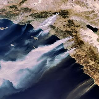
People are not yet suffering, but trees are. Forests in the West are dying, most impressively by burning. The damage done by wildfires in the U.S., the vast majority of them in the West, has soared since the late 1980s. In 2006 nearly ten million acres were destroyed—an all-time record matched the very next year. With temperatures in the region up four degrees F over the past 30 years, spring is coming sooner to the western mountains. The snowpack—already diminished by drought—melts earlier in the year, drying the land and giving the wildfire season a jump start. As hotter summers encroach on autumn, the fires are ending later as well.Yes. We experienced this just this last year in California:

More people, more polluted oceans and dead zones, less potable water, breaking infrastructure, more contaminates.
No politician will ever admit the world is changing as we speak. Especially the Bush Republicans. It is not good for the economy to go negative. And we're going to have to take drastic steps to change our comfortable lifestyles and habits. No politician will dare tell us to do it.
We're going to have to do it ourselves.
(Psst .. turn off your taps.)
Friday, February 15, 2008
We've been assuming the oceans could handle anything we've done to them
But they haven't:
What with continent-sized plastic-filled gyres and dead zones, I'd say we're doing a heck of a job!
Santa Barbara, CA (AHN) - A recent study revealed that there are very few ocean areas, if any, that remain untouched by human influence and activities.
Upon mapping out the areas influenced by humans in some way, scientists discovered that every ocean in the world had been tampered with or affected in some way by human activities, such as fishing, pollution or global warming.
The findings were determined by a global map created by a University of California team. The map indicated the level and nature of damage to marine ecosystems, revealing the parts of the world's oceans that might have managed to remain pure and pristine.
A range of scores of 17 kinds of human influence was assigned, and then tallied for every ocean, eventually showing the extent of human impact on the world's waters.
[snip]
The map showed that 40 percent of the marine ecosystems garnered either a "medium high" or "high" human impact, taking in factors such as shipping lanes, oil and gas exploration and invasive species, according to Bloomberg. The analysis looked into the effects on reefs, continental shelves and mangroves.
The study revealed that the areas of the Mediterranean, east Caribbean, Persian Gulf, Norwegian Sea, Bering Sea, North America's east coast and the Sri Lanka waters were the ones most affected by human activity.
What with continent-sized plastic-filled gyres and dead zones, I'd say we're doing a heck of a job!

Monday, January 21, 2008
A sign of the end of days!
Or the revenge of the sea creatures over the Dead Zone. Or a biblical prophecy of being swamped with tentacled blobby things in the middle of the continent because of being wingnuts....
Or maybe.... (/crashing organ chords...) it's spawn of the ... BLOB!Tulsa, OK (AHN) - Surges of jellyfish were reported to have suddenly appeared in local water bodies of Oklahoma. The sea creatures have been found in more than 20 counties within the state.
The sudden appearance of the jellyfish was not seen as a threat, as explained by Barry Bolten, the head of the fisheries department of the Oklahoma Department of Wildlife. He explained that the species found all over the state was not as hazardous as its other cousins.
Tuesday, December 18, 2007
Wait a minute... does this make sense?

We are growing corn to make ethanol because we want to be less reliant on foreign oil (no more wars) and more environmentally friendly (fight global warming), right? So when businesses activate a coal burning plant to process ethanol (which is actually an extremely inefficient carbon to burn), isn't that kinda defeating the purpose? When we ignore the fact that some biofuels actually damage the enviroment more, isn't that kinda defeating the purpose? And when the ethanol mega farms begin using too much water from the ancient acquifers in Iowa, isn't that kinda defeating the purpose?
So when we grow so much corn that we flood the rivers with fertilizer and it poisons everything downstream and way out into the Gulf of Mexico, isn't that kinda defeating the purpose?:
JEFFERSON, Iowa - Because of rising demand for ethanol, American farmers are growing more corn than at any time since World War II. And sea life in the Gulf of Mexico is paying the price.Who is getting rich off this nonsense? You want to take a guess? Maybe Bush's cronies or the Megafarms?The nation's corn crop is fertilized with millions of pounds of nitrogen-based fertilizer. And when that nitrogen runs off fields in Corn Belt states, it makes its way to the Mississippi River and eventually pours into the Gulf, where it contributes to a growing "dead zone" — a 7,900-square-mile patch so depleted of oxygen that fish, crabs and shrimp suffocate.
The dead zone was discovered in 1985 and has grown fairly steadily since then, forcing fishermen to venture farther and farther out to sea to find their catch. For decades, fertilizer has been considered the prime cause of the lifeless spot.
Update 12/19: Carl at Simply Left Behind makes the same points.
Sunday, July 29, 2007
The dead zone is the third largest ever mapped
No, it's not Bush's brain nor Cheney's heart, it's the ocean area off of Louisiana and Texas:
Update: Bryan of Why Now?, Steve Bates of The Yellow Doggerel Democrat, and Hipparchia of Over the Cliffs, Onto The Rocks tell me it's been going on for a while, due to fertilizer run off and man made pollution, and offered links here and here and here.
NEW ORLEANS, Louisiana (AP) -- The oxygen-poor "dead zone" off the Louisiana and Texas coasts isn't quite as big as predicted this year, but it is still the third-largest ever mapped, a scientist said Saturday.I had no idea. Somehow this huge dead area is ... a common occurence? How long has this been happening?Crabs, eels and other creatures usually found on the bottom of the Gulf of Mexico are swimming in crowds on the surface because there is too little oxygen in their usual habitat, said Nancy Rabalais, chief scientist for northern Gulf hypoxia studies.
"We very often see swarms of crabs, mostly blue crabs and their close relatives, swimming at the surface when the oxygen is low," she wrote in an e-mail from a research ship as it returned to Cocodrie from its annual measurement trip.
Eels, which live in sediments 60 to 70 feet below the water surface, are an even less common sight, she said.
The 7,900-square-mile area with almost no oxygen, a condition called hypoxia, is about the size of Connecticut and Delaware together. The Louisiana-Texas dead zone is the world's second-largest hypoxic area, she said.
Update: Bryan of Why Now?, Steve Bates of The Yellow Doggerel Democrat, and Hipparchia of Over the Cliffs, Onto The Rocks tell me it's been going on for a while, due to fertilizer run off and man made pollution, and offered links here and here and here.
Subscribe to:
Posts (Atom)